Sunrise at 05:31 and Sunset at 17:47. It's light
Latitude. 13.9833333°, Longitude. 124.2666667°
Geography
The municipality of Bagamanoc is located at the northeaster part of the province of Catanduanes directly facing the vast Pacific Ocean. Its total land are is 93.3 square kilometers, and is about 62.0 kilometers away from the capital town of Virac. Its location is somewhat disadvantageous in its quest for development because of its distance form the capital town and moist in particular it is open to the sea, whereby typhoon surge often wrought havoc to the shorelines particularly to the built-up areas during typhoons.
Bagamanoc is located between latitude 13*53’00” and longitude 124*11’00” to 124*23’00” to be exact. It is bounded on the eastern side by the Pacific Ocean, on the northwestern side by the municipality of Pandan, western side by the municipality of Caramoran, and on the south by the municipality of Panganiban.
Barangays
Bagamanoc is politically subdivided into 18 barangays.
|
|
Topography
History
Bagamanoc Proper was yet nameless, unmarked by the footprints of men. On its sandy soil roamed numerous ferocious quadrupeds of all sizes and wild fowls. There yet stood a variety of big, tall century old trees interlaced with long, tapering some thorny vines brownish with age. Multicolored birds played, song mated laid their eggs on the branches and fed on their luscious fruits.
The crescent, bare grayish black shores you now see was yet less curved, where the low tide waves now lap at the shoreline, grow a row of thick of bush of green pandan shrubs unmolested by the clutches of the claws of the sea. Not far from this place, at what is known as Bagatabao, but more island of the swamp, Bagamanocnons now called Taraga, there was already a chicken raising settlement place from the inhospitable plateau of Panay Island (Catanduanes).
The settlement was bounded on the East and North by the sea, blocked by a swamp and a hostile hill on the South and pressed by the crocodile-infested mouth of what is now known as the Bagamanoc River on the West. Confined to a limited territory by natural forces, the settlement could hardly feed and shelter itself. Moreover, frequent raids by corsairs from Mindanao, Jolo or Borneo for slaves had a serious problem to their existence.
One day, a daring and adventurous young man from the tribe forced his way across the mouth of the river to look for rattan needed for the repair of his future bride’s family house. Going westward by the shoreline, he finally turned left for the business of venture but before he cut an uphill distance, he saw what appeared to be a chicken flying along just above the tallest leaves of pandan shrubs festooning the sea. Back in his tribe, he told the clan on what he saw of the beauty of the place, its abundance with food and building materials and the defense is offered from the pirate’s raid. But as the place has no name to say when referring to that “discovered land” every time anybody talk of the place, they would call it “BAGAMANOC” which means the place was like a “chicken” the very meaning of Bagamanoc.
To detect the coming of the Moro raids, the people erected a watchtower at where the sea laps at the shore nearest the present Municipal Hall. In spite of the tower, many Bagamanocnons still fell into the corsairs’ hand. When the Spaniards came, they found the place a thriving community. They converted the people into Christianity and made a settlement into a municipality under a governadorcillo. Under Spain, the town people constructed a concrete church and municipal hall of stones, limes, molasses and eggs. However, even under the Spaniard rule, Bagamanocnons did not fully submit to the Spanish dominion, although fully sold out to Christianity. During the revolution of 1898-1901, the Bagamanocnon relied their support to the Filipino Revolutionist. In fact, a bloody skirmish took place at Mapulang Labo, where the late Apolonio Cueva skillfully beheaded an American Officer mounted on a horse. When the Americans reorganized the municipal government, the town was reduced to a mere town of Viga, later of Payo, until Bagamanoc became a municipality again in 1950.
Bagamanoc is used to be called a small town of big people and properly so. She had produced a hundred of professionals scattered all over the archipelago who in their modest way are making a name for themselves and for their birth place. The country’s representative to the “Tokyo Olympic Games” in 1924. in the discus throwing event came from this town and the second Catanduanes congressman under an independent Philippines hails from here.As of lately and during the time where the American Bases are still here in the Philippines,Bagamanoc has also been the site of the LORAN ( Long Range Navigation Facilities ) Station primarily installed to protect the country from external threats, among others.
Economy
Agriculture Sector
The major crops in the municipality are food crops (rice, corn, root crops, vegetables and legumes) and cash crops (abaca and coconut). Large parcel of riceland are situated at barangays Quezon, Sta. Teresa, Antipolo and Bagatabao Magsaysay, and Bugao. Abaca and coconut plantation are found in all barangay, except barangays Poblacion, Sta. Mesa and Sta. Teresa.
The municipality is not identified as a key Livestock Development Area but there are areas in some barangays which are conducive to livestock raising particularly carabao and cattle. These are barangays San Isidro and Suchan. Livestock raising in the municipality are mostly backyard and as work animals.
Identified fishing development areas are the barangays of Quezon, Bagatabao, Quigaray and Suchan. Most of these fishponds are now for family subsistence and not for commercial production due to its physical state. Asides from the fishponds, large fishing ground abounds in the locality being a coastal area. These are the Bagamanoc Bay. Loroman, Late and Quigaray Cove.
Commerce and Trade Sector
The municipality does not have any big commercial establishment nor have much trade and commercial activities to speak of. Existing are about 96 locally registered and license commercial establishment throughout the municipality ranging from a small eatery to retail and wholesale stores. Most of the bigger stores are found at the municipal commercial strip or commercial business district.
Besides from the commercial strip, the municipality has the Municipal Public Market, which is strategically located near the slaughterhouse, Municipal Training Hall and the Bus and Jeepney Terminal.
Almost all the commercial consumers products are being bought at commercial establishments at Virac, which are brought home daily loaded on a passenger’s jeepney/bus or a cargo truck. Agricultural crops are sold directly to buying commercial establishment at Virac.
Tourism
There is no specific tourism activities in the municipality, although there are potential areas endowed with natural attributes and resources that are conducive to recreation, leisure and other wholesome experiences which can provide the purpose for visitors, excursionist and vacationist. Basically the locality is coastal, thus there sprawling beaches, lagoons, shoals, coves wherein one can frolics and do some fishing. There are also some river and falls where in anybody could have some picnic or excursion. There is also the former LORAN Station Buildings (US Coast Guard Station) located atop a hill and overlooking coastal strips of beaches and the Pacific Ocean.
Among those potential sites are the falls at Paday along Panuto and Maragkiw River at Bacak, Pantalan at Caningan River, Quezon and Cagnipa at Barangay San Vicente overlooking the sea and a nsilet. Included are the strip of beaches like Bugao-Pogtangan Beach, Late Beach and Cabusiw-Dayhagan Beaches along the blue seas and corals where in one can do swimming and scuba diving.
Industry
The municipality is an agricultural base community whereby necessary resources for agro-industrial undertakings are available. Abundant raw materials from the forest and other agricultural products could be utilized for a cottage or home industry. The vast seas could be tapped as source for raw materials for fish and marine processing business and other livelihood activities for the local fisher folks. Besides form the abundant raw materials, adequate labor force is readily available.
There are no established industry in the locality, what present are small scale rice mills, an off and on small home furniture, leather wear and nipa shingle making.
Climate
Like other municipalities of the eastern section of the province and province itself, the climate of the municipality is type II of the Coronas Classification for climatic zones, best described as having no distinct dry season with a very pronounced rainfall, usually heavy during the month from October to January.Typhoon is very much prevalent in this locality due to its geographical positioning fronting the Pacific Ocean.
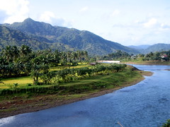
Picture depict the river side along the road going to Bagamanoc. Taken from on top of a speeding bus on the way to Bagamanoc on the island of Catanduanes.
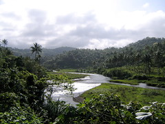
A river running throught the town of Minaili.
I am inviting you to visit our town, on my next bog I will try my best to show the LORAN Station area and the Panay Island where beach, white sand large sea waves seen specially the month of November to January.
Unti next....
Cheers,